| Return to Configuration Overview |
|---|
Geocoding is the process of finding associated geographic coordinates (i.e., latitude, longitude) from other geographic data, such as street addresses. In order to display data on a map, some geographic information is required. If your data contains address information only, the mapping service you select will perform the geocoding to convert the addresses to geographic coordinates. Sometimes geocoding results vary, depending on the service used.
If you have latitude and longitude information for your data points, your map may display more quickly since no geocoding is required. Geocoding is performed to generate the latitude and longitude for the addresses provided.
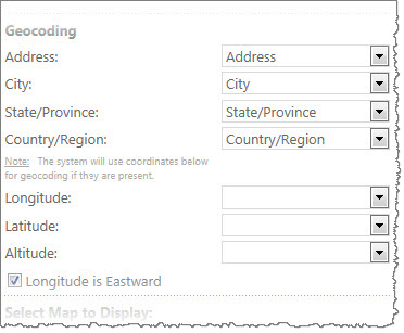 Regardless of your data source, select the columns for Address, City, State/Province, and Country/Region. If your data already contains geographic coordinates, select the columns that contain Latitude, Longitude, and optionally, Altitude.
IMPORTANT: If you configure list columns for Longitude, Latitude, and optionally Altitude, these coordinates will be used for mapping and Address, City, State, and Country information will NOT be used. It is not necessary to configure Address/City/State/Country if you have configured Longitude/Latitude/Altitude. If a location has address information but no values for Lat/Long and the Longitude/Latitude/Altitude was configured in the web part tool pane, the location will not be plotted. In other words, it is not currently possible to map some locations using Lat/Long and others using address information.
Longitude is Eastward: Indicates whether the coordinates for longitude are east (selected check box) or westward facing (unselected check box). The default is westward facing.
| Return to Configuration Overview |
|---|