Issue:
You are plotting locations based on Address information and one of the markers appears in the wrong place.
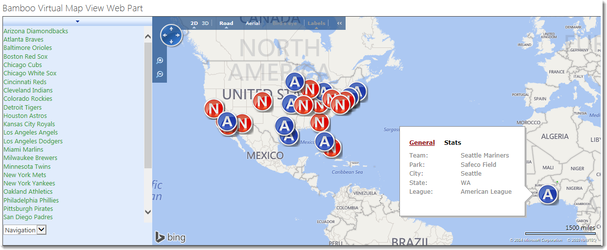
See the example below where we are using BingTM Maps to display baseball fields in the USA. The marker for the Seattle Mariners appears in Africa, but the City and State values are Seattle and WA respectively. Why doesn’t it show up in Washington state in the USA?
NOTE: Depending on the data you are trying to display, this may occur when using GoogleTM maps as well.
Resolution:
There are a few things you can try when you see an issue like this with the Virtual Map View:
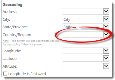
- One thing to note about this map display scenario is that we are passing City and State without additional information such as Address (street) or Country to the Map Provider. As you can see, this works for most of the markers.
 If we add Country and don’t change the map provider, the Seattle Mariners will appear where they should. In other words, in this scenario the BingTM mapping service needed a little more information in order to locate Safeco Field properly.
IMPORTANT: Unless all the geocoding parameters are mapped, only 20 locations will be mapped if using the BingTMmap provider. The GoogleTM map provider doesn’t have this limitation in SP2013. All locations will be plotted on the Google map with partial geocoding parameters.
NOTE: If you are using SP2010 with either the BingTM or GoogleTM map provider, ALL geocoding parameters are required in order for any data to be displayed.
- The available Map Providers (i.e., GoogleTM and BingTM) use different geocoding algorithms and sometimes one works better than the other for particular datasets. For example, with the same original dataset (that does NOT include Country), the GoogleTM map provider puts the Seattle Mariners Safeco Field in the right location:

-
If you have latitude and longitude information for your locations, the map providers can plot those rather than try to geocode the address information you provide. This will probably result in the most accurate display, regardless of the Map Provider. It will also result in the quickest display since the mapping provider doesn’t need to geocode first; this saves processing time.
IMPORTANT: If you configure the web part with a column value for Latitude and Longitude, only the items with values in those columns will be plotted on the map – even if you have also configured your web part with address information. It is not currently possible to have some markers plotted using the address information and some with the Latitude and Longitude.